Geoinfra Technologies India in Thiruvananthapuram, Kerala: Geospatial Training & Research Institute
Live online classes • Real projects • 100% placement assistance
Introduction
Kerala receives the highest number of GIS training enquiries from students and professionals aiming for a geospatial career. At GeoInfra Technologies India, we train them with the right tools and techniques needed to build a strong future in GIS. Our programs prepare learners for roles such as GIS Analyst, GIS Engineer, GIS Project Manager, GIS Technician, GIS Associate, GIS Consultant, GIS Specialist, and Web GIS Developer.
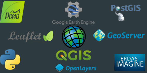
We stay updated with the latest technology to give our students maximum knowledge and skills. Our training covers ArcGIS Pro, Google Earth Engine (GEE), Python, Artificial Intelligence, Web GIS Development, QGIS, Spatial Databases, Web Mapping, GIS Application Domains, Hands-On Projects, and Capstone Projects.
With over 8 years of experience, we specialize in GIS training and development. We are a PAN-India training provider dedicated only to GIS and Remote Sensing training and research.
The Founding Vision
Geoinfra Technologies India in Thiruvananthapuram was founded with a clear and ambitious vision: to bridge the gap between geospatial technology and its practical applications, contributing to the socio-economic development of the region and beyond. The institute’s mission is to provide a profound understanding of GIS and Remote Sensing while nurturing the next generation of experts in these fields.
Courses and Training
Geoinfra Technologies India offers a comprehensive range of courses and training programs designed to cater to a diverse audience, from beginners to experienced professionals:
GIS Fundamentals: A foundational course that introduces beginners to the core principles and applications of GIS.
Remote Sensing Techniques: An in-depth exploration of the science behind remote sensing and its versatile applications in fields such as agriculture, forestry, urban planning, and disaster management.
Advanced GIS and Spatial Analysis: Tailored for individuals with prior GIS knowledge, this course covers advanced spatial analysis techniques and their practical applications.
GIS and Remote Sensing in Environmental Management: A specialized course focusing on the critical role of geospatial technology in environmental protection and sustainable management.
Geospatial Programming: An advanced course designed for those interested in developing programming skills for GIS applications.
GIS and Advanced Analytics with Artificial Intelligence (AI) ![]()
Modern Infrastructure
Geoinfra Technologies India in Thiruvananthapuram prides itself on its state-of-the-art infrastructure equipped with the latest GIS and remote sensing software and tools. Students have access to industry-standard software, including ArcGIS, QGIS, ERDAS, and ENVI. The institute’s dedicated GIS and remote sensing labs provide students with hands-on experience, allowing them to apply their theoretical knowledge to real-world projects.
Expert Faculty
The institute’s core strength lies in its experienced and knowledgeable faculty members. These experts bring real-world experience and industry insights into the classroom, offering students guidance and mentorship that goes beyond the coursework. Their rich expertise and research contributions enrich the learning experience, making Geoinfra Technologies India in Thiruvananthapuram a hub for geospatial excellence.
Research and Projects
Geoinfra Technologies India actively engages in research and projects in collaboration with government agencies, environmental organizations, and private sector partners. These initiatives offer students the opportunity to work on real-world projects, contribute to the advancement of GIS and Remote Sensing technologies, and gain practical experience in the field. The institute’s commitment to research and development keeps it at the forefront of technological advancements in the geospatial domain.
Community Engagement
Geoinfra Technologies India in Thiruvananthapuram doesn’t limit its activities to the classroom. The institute actively engages with the local community through workshops, seminars, and awareness programs. These outreach efforts play a pivotal role in spreading knowledge and raising awareness about the significance of GIS and Remote Sensing in the contemporary world, particularly within the lush and culturally rich landscape of Kerala.
Conclusion
Geoinfra Technologies India in Thiruvananthapuram stands as a testament to geospatial excellence, innovation, and community engagement. With its comprehensive courses, advanced infrastructure, expert faculty, and commitment to research and development, it is shaping the future of geospatial technology not only in Thiruvananthapuram but also on a national scale. If you are looking to unlock the potential of Geographic Information Systems and Remote Sensing, Geoinfra Technologies India in Thiruvananthapuram is the ultimate destination. It’s more than just an institute; it’s a crucible of learning, discovery, and transformation in the heart of “God’s Own Country.”


Geographic Information Systems (GIS) is a powerful tool used worldwide. It helps collect, manage, and analyze data linked to location. From city planning to disaster management, GIS plays a key role. The demand for skilled GIS professionals is rising in India, especially in Kerala.
If you are looking for GIS training in Kerala, you are on the right track. This field opens doors to careers in mapping, research, government projects, and private firms. Training in GIS and remote sensing will give you both skill and confidence.
Why GIS Training in Kerala is Important
Kerala is a state known for strong education and tech growth. Many government and private projects in Kerala need GIS experts. From land records to forest data, GIS is used everywhere. This demand has created a need for top GIS training institutes in Kerala.
Students and working professionals benefit from learning GIS. Whether you want a career shift or skill growth, affordable online GIS courses in Kerala make it possible. With proper training, you can work in India or abroad.
Online GIS Courses in Kerala
Today, many learners prefer online classes. They are flexible and save time. Institutes now offer Kerala online GIS courses and Kerala online GIS certificate courses. These programs cover the basics of GIS, remote sensing, GPS, and data analysis.
If you want the best online GIS training in Kerala, look for a course with real projects and expert trainers. Practical learning is key in GIS. A good course should train you to use software like ArcGIS, QGIS, and ERDAS.
GIS and Remote Sensing Online Course in Kerala
Remote sensing is the art of collecting data from satellites and drones. When linked with GIS, it helps in real-world applications. For example, flood mapping, crop studies, and urban growth tracking.
A GIS and remote sensing online course in Kerala will teach you both. Students can learn to process images, analyze patterns, and present results with maps. This dual skill is valuable in research, government, and private firms.
Affordable Online GIS Courses in Kerala
Cost is a concern for many students. The good news is that affordable online GIS courses in Kerala are available. These courses provide quality learning without a high fee.
Institutes like GeoInfra Technologies India aim to give value at a fair price. They train students with industry-focused methods. This makes the training both practical and job-ready.
What You Learn in GIS Training
GIS training is not just about software. It covers theory, practice, and real-world work. Here are some topics covered:
Basics of maps and spatial data
GIS software use (QGIS, ArcGIS, ERDAS)
GPS and field data collection
Remote sensing image analysis
Land use and land cover mapping
Water resource and forest mapping
Web GIS and open-source tools
By the end of training, you will be ready for projects. You can apply for jobs in urban planning, agriculture, defense, or IT.
Why Choose GeoInfra Technologies India
GeoInfra Technologies India is a trusted name in GIS training in Kerala. We focus on skill development through hands-on practice. Our trainers have strong field and teaching experience.
We provide both classroom and online learning. You can pick what suits your schedule. Our Kerala online GIS certificate courses are designed for both beginners and professionals.
Here’s what sets us apart:
Expert trainers with real project experience
Affordable fee structure
Flexible online and offline modes
Updated software and tools
Industry-relevant projects
Placement guidance and career support
Career Options After GIS Training
GIS opens doors in many industries. With GIS and remote sensing training in Kerala, you can work as:
GIS Analyst
Remote Sensing Specialist
Urban Planner
Cartographer
Survey Officer
Research Associate
GIS Developer
Many government departments and private companies in Kerala need these skills. You can also apply for global opportunities.
Who Can Join GIS Training
Anyone with interest in maps and data can join. The course is ideal for:
Students in geography, geology, or environmental studies
Civil engineers and planners
IT professionals
Working people seeking career growth
Researchers in agriculture, forestry, or water studies
No advanced coding skills are needed. Basic computer knowledge is enough.
FAQ on GIS Training in Kerala
Q1: What is the best online GIS training in Kerala?
The best course is one that covers both theory and practice. GeoInfra Technologies India offers complete online GIS courses in Kerala with real projects.
Q2: Can I join a GIS and remote sensing online course in Kerala?
Yes. Many institutes, including GeoInfra Technologies India, provide GIS and remote sensing online courses in Kerala. They cover satellite data, mapping, and GIS tools.
Q3: Is there an affordable online GIS course in Kerala?
Yes. GeoInfra Technologies India offers affordable online GIS courses in Kerala without cutting quality. You get expert guidance and hands-on work.
Q4: Do I get a certificate after completing GIS training?
Yes. You will receive a certificate after completing the Kerala online GIS certificate course. This adds value to your career.
Q5: What are the job options after GIS training in Kerala?
You can work as a GIS Analyst, Remote Sensing Expert, Cartographer, or Planner. Kerala has demand in both government and private sectors.
Q6: Do I need a technical background for GIS training?
No. Anyone can learn GIS. Basic computer knowledge is enough.
Conclusion
GIS is one of the most useful tools today. If you want to build a strong career in this field, GIS training in Kerala is the right step. With online options, affordable fees, and expert trainers, you can gain skills that will set you apart.
GeoInfra Technologies India is here to guide you. With quality training, practical learning, and career support, we help you achieve your goals.
Contact Us
GeoInfra Technologies India
Website: www.geoinfratechnologiesindia.com
Email: info@geoinfratechnologiesindia.com, geoinfratechnologiesindiamail@gmail.com
Phone: +91 6003787569, +91 6363595601
Landline: 02269711506 (All available on WhatsApp)
Testimonials
Courses
1 Year GIS Analyst PGP (Post Graduation Program) [12 Months]
This course is designed to cover A-Z of GIS & Remote Sensing (A Full Stack GIS Developer Program)
Course Duration: 12 Months
Class Duration: upto 2 hours per class / Monday to Saturday / tri-weekly basis
For Class Timings Contact us.
Mode of Training: Instructor Led Live Online/Offline/Hybrid Classroom Training.
INR Price: Rs 72,000/- (Limited Period Offer)
USD: $ 1500/- (For International Students, Inc. all taxes)
100% PLACEMENT ASSISTANCE
This Course includes Comprehensive Drone Technology Program & GIS and Advanced Analytics with Artificial Intelligence (AI)
Explore→
Post Graduate Certification Program (PGCP) in GIS & Remote Sensing [6 Months]
Course Duration: 6 Months
Class Duration: upto 2 hours per class / Monday to Saturday / tri-weekly basis
For Class Timings Contact us.
Mode of Training: Instructor Led Live Online/Offline/Hybrid Classroom Training.
INR Price: Rs 45,000/- (Limited Period Offer)
*Fee concession for students from Northeast
USD: $ 850/- (For International Students, Inc. all taxes)
Explore→
3 Months Advanced GIS & Remote Sensing Development Training [3 Months]
Course Duration: 3 Months
Class Duration: 1 hour per class / Monday to Saturday / Tri – Weekly Classes
For Class Timings Contact us.
Mode of Training: Instructor Led Live Online/Offline/Hybrid Classroom Training.
INR Price: Rs 30,400/- (Limited Period Offer)
*Fee concession for students from Northeast
USD: $ 550/- (For International Students, Inc. all taxes)
Explore→
Certificate Course in GIS [1 month]
Course Duration: 1 Month
Class Duration: 1 hour per class / Monday to Friday / 5 class per week
Corporate Certificate Training Provided Post Training Completion.
For Class Timings Contact us.
Mode of Training: Instructor Led Live Online/Offline/Hybrid Classroom Training.
INR Price: Rs 23,000/- (Limited Period Offer)
*Fee concession for students from Northeast
USD: $ 275/- (For International Students, Inc. all taxes)
Explore→
15 Days Fundamentals of GIS Development Training[15 Days]
Course Duration: 15 days
Class Duration: 1 hour per class / Monday to Friday / 5 class per week
Certificate Training
For Class Timings Contact us
Mode of Training: Instructor Led Live Online/Offline/Hybrid Classroom Training.
INR Price: Rs 15,500/- (Limited Period Offer)
USD: $ 200/- (For International Students, Inc. all taxes)
Explore→

GIS Training
Training students and Professionals from India and Abroad to make a career as a GIS Analyst | GIS Engineer | GIS Project Manager | GIS Technician | GIS Associate | GIS Consultant | GIS Specialist | Web GIS Developer

GIS & Remote Sensing Research
Ongoing research on what evolving GIS Industry needs from Freshers as Skills to make them Job Ready and what additional skills can be aquired by professionals to updrade their current skills to excel in their field of expertise.

National & International Standards
Maintaining a PAN India and International Standard of Certification and adding up new MoU Collaborations to help our Students and Professionals get maximum Benefit of our GIS certification Programs.

Academic Partnerships & Workshops
We conduct yearly workshops and Seminars PAN India to bring awareness among the students, faculties and various other stakeholders on how GIS & Remote Sensing can bring in a new revolution in the Industries.
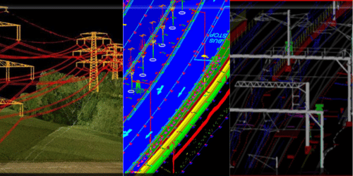
Industry Softwares
We equip our trainees with Industry Best Softwares for Best Results and Outcome in the GIS Industry — from LiDAR Data Processing to 2D Satellite Image Analysis, from GIS Mapping to Web GIS Development.
Best GIS and Remote Sensing Training Institute in Thiruvananthapuram, Kerala
Looking for the best GIS and Remote Sensing training institute in Kerala?
At Geoinfra Technologies India, we provide industry-focused GIS & Remote Sensing courses in Thiruvananthapuram, designed to help students and professionals build successful careers in the rapidly growing geospatial industry.
Where Our Training Makes an Impact
Environment & Climate – Biodiversity mapping, carbon monitoring, climate impact studies.
Urban Planning & Smart Cities –Infrastructure planning, land-use mapping, 3D city models.
Agriculture & Forestry – Precision farming, crop monitoring, forest resource management.
Water Resources & Hydrology – Flood risk modeling, watershed management, HEC-RAS simulations.
Disaster Management –Hazard mapping for floods, landslides, and earthquakes using geospatial tools.
