Geoinfra Technologies India in Dehradun, Uttarakhand
Top GIS & Remote Sensing Training in Dehradun, Uttarakhand — Geoinfra Technologies India®
Introduction
Tucked into the foothills of the Himalayas, Dehradun is an emerging hub of education and tech, and right here is Geoinfra Technologies India®—your go-to place for practical, career-focused learning in GIS and Remote Sensing. We make sure you don’t just learn—it becomes part of what you do.
Our Vision
We started Geoinfra Dehradun to bridge the gap between GIS theory and real-world impact. We’re not here to just teach software—we’re here to help you use those tools to build smarter agriculture, better environmental planning, and resilient infrastructure in Uttarakhand and beyond.
Courses & Training Offered
Our programs are built to meet learners wherever they are—whether you’re curious or upgrading your professional toolkit:
GIS Fundamentals – Learn the basics, from maps to software, in real-world context.
Remote Sensing Techniques – Dive into how satellite data helps agriculture, forestry, and disaster response.
Advanced GIS & Spatial Analysis – Ready for more? Learn complex spatial tools that agencies rely on.
GIS for Environmental Management – Use geospatial tech to champion sustainability.
Geospatial Programming – Build projects with code (Python, scripting, automation).
Hands-On Infrastructure
We’re not just teaching; we’re doing. At Geoinfra Dehradun, you work with genre-standard software like ArcGIS, QGIS, ERDAS, and ENVI in dedicated labs—so you can turn theory into real results.
Learning from Industry Pros
Our faculty isn’t just experienced—they’ve worked on projects outside the classroom. Their guidance comes from years of fieldwork, consultancy, and innovation. Learn directly from people who’ve actually been there.
Research & Project Opportunities
Want hands-on experience? We partner with local agencies and environmental organizations on real projects. You might help map natural resources or plan urban systems—skills that look great on a resume.
Community & Outreach
We’re not limited by classroom walls. Geoinfra hosts workshops and seminars in Dehradun to spread geospatial awareness. We’re part of the community here, working with schools, colleges, and local groups to make GIS a tool everyone understands.
Here’s Why Geoinfra Dehradun Stands Out
Real projects, not slide decks.
Flexible courses (online, offline, hybrid).
Tech tools that match the industry’s.
Local mentors with field experience.
Research collaborations with real-world impact.
A supportive community that includes you.
Your Next Steps
If you’re studying Geography, Civil Engineering, Environmental Science, or Urban Planning—or even if you’re shifting careers—Geoinfra Dehradun trains you to stand out.
Reach Us:
Address: Orion Tower, 403, Christian Basti, Guwahati – 781019
Phone: +91-8979846877 / +91-6003787569
Email: info@geoinfratechnologiesindia.com

1 Year GIS Analyst PGP (Post Graduation Program) [12 Months]
This course is designed to cover A-Z of GIS & Remote Sensing (A Full Stack GIS Developer Program)
Course Duration: 12 Months
Class Duration: upto 2 hours per class / Monday to Saturday / tri-weekly basis
For Class Timings Contact us.
Mode of Training: Instructor Led Live Online/Offline/Hybrid Classroom Training.
INR Price: Rs 72,000/- (Limited Period Offer)
USD: $ 1500/- (For International Students, Inc. all taxes)
100% PLACEMENT ASSISTANCE
This Course includes Comprehensive Drone Technology Program & GIS and Advanced Analytics with Artificial Intelligence (AI)
Explore→
Post Graduate Certification Program (PGCP) in GIS & Remote Sensing [6 Months]
Course Duration: 6 Months
Class Duration: upto 2 hours per class / Monday to Saturday / tri-weekly basis
For Class Timings Contact us.
Mode of Training: Instructor Led Live Online/Offline/Hybrid Classroom Training.
INR Price: Rs 45,000/- (Limited Period Offer)
*Fee concession for students from Northeast
USD: $ 850/- (For International Students, Inc. all taxes)
Explore→
3 Months Advanced GIS & Remote Sensing Development Training [3 Months]
Course Duration: 3 Months
Class Duration: 1 hour per class / Monday to Saturday / Tri – Weekly Classes
For Class Timings Contact us.
Mode of Training: Instructor Led Live Online/Offline/Hybrid Classroom Training.
INR Price: Rs 30,400/- (Limited Period Offer)
*Fee concession for students from Northeast
USD: $ 550/- (For International Students, Inc. all taxes)
Explore→
Certificate Course in GIS [1 month]
Course Duration: 1 Month
Class Duration: 1 hour per class / Monday to Friday / 5 class per week
Corporate Certificate Training Provided Post Training Completion.
For Class Timings Contact us.
Mode of Training: Instructor Led Live Online/Offline/Hybrid Classroom Training.
INR Price: Rs 23,000/- (Limited Period Offer)
*Fee concession for students from Northeast
USD: $ 275/- (For International Students, Inc. all taxes)
Explore→
15 Days Fundamentals of GIS Development Training[15 Days]
Course Duration: 15 days
Class Duration: 1 hour per class / Monday to Friday / 5 class per week
Certificate Training
For Class Timings Contact us
Mode of Training: Instructor Led Live Online/Offline/Hybrid Classroom Training.
INR Price: Rs 15,500/- (Limited Period Offer)
USD: $ 200/- (For International Students, Inc. all taxes)
Explore→
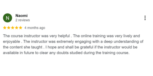
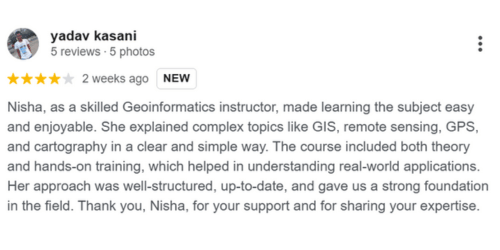
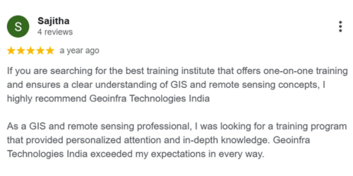
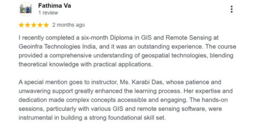
Testimonials