1 Year GIS Analyst PGP (Post Graduation Program) [12 Months]
“YOUR CAREER IS OUR RESPONSIBILITY”
AI + GIS
THE FUTURE IS HERE
Geoinfra Technologies India®
About
The 1-Year GIS Analyst Post Graduate Program (PGP) at Geoinfra Technologies India is an intensive, industry-driven training program designed to transform graduates and professionals into highly skilled GIS Analysts.
The course is structured to provide 10 months of advanced training + 2 months of internship, ensuring both conceptual depth and workplace-ready expertise. With a blend of core GIS fundamentals, cutting-edge tools, Drone & LiDAR technology, and AI integration, participants gain the skills required to address real-world spatial challenges across multiple domains.
Software & Tools Covered
ArcGIS 10.x | ArcGIS Pro | QGIS | Erdas Imagine | Microstation | LiDAR Processing | Photogrammetry | 3D Mapping | ArcSWAT | Google Earth Engine | Python Libraries (GeoPandas, Rasterio, PyQGIS, etc.) | AI Tools | Web GIS Platforms
Who can opt?
This program is open to graduates and postgraduates from disciplines such as Geography, Geology, Environmental Science, Civil Engineering, Planning, and Computer Science. It is equally suitable for BSc/MSc students, PhD scholars, researchers, and academicians aiming to strengthen their geospatial expertise. Additionally, working professionals seeking career growth, transition, or upskilling are encouraged to join.
Key Highlights
GIS & Remote Sensing Foundations: Spatial data models, projections, cartography, and visualization
Remote Sensing & Image Analysis: Digital image processing, classification, and interpretation
Spatial Databases & Data Management: Managing geodatabases, PostGIS, and metadata standards
Advanced GIS Applications: Terrain & hydrology analysis, network modeling, 3D mapping
Drone & LiDAR Technology: Drone mapping workflows, photogrammetry, LiDAR point cloud processing
Programming & Automation: Python, Google Earth Engine, ArcPy, QGIS plugins
Web GIS Development: GeoServer, ArcGIS Online, QGIS2Web, interactive dashboard creation
AI & Big Data in GIS: Machine learning, predictive modeling, and geospatial intelligence
Domain-Specific GIS: Urban planning, environment, agriculture, forestry, disaster management, mining, public health, and more
Capstone Project + Internship: Industry-level project to build a professional portfolio
Table of Contents
Introduction to Geographic Information Systems (GIS) – Concepts and Applications
Understanding the basics of GIS: Definition, components and types of data.
Real-world applications of GIS in various industries such as urban planning, environmental management and emergency response.
Introduction to GIS software and tools – overview of popular platforms like ArcGIS, QGIS and Google Earth.
Spatial Data Acquisition and Management
Sources of Spatial Data: Introduction to different sources of spatial data including remote sensing, GPS, surveys and crowd-sourced data.
Data Formats and Standards: Understanding common GIS data formats (shapefiles, geodatabases, GeoTIFF, etc.) and metadata standards.
Data Collection Techniques and Considerations: Techniques for data collection, data accuracy considerations and metadata creation.
Data Quality and Metadata Standards: Understanding data quality issues and metadata standards for spatial data.
Data collection sources: Survey of India, Bhukosh, Bhuvan, USGS EarthExplorer.
Spatial Analysis Techniques
Spatial Analysis Concepts and Methodologies: Introduction to spatial analysis techniques such as overlay operations, spatial queries, buffering and proximity analysis.
Advanced Spatial Analysis Techniques: Introduction to more advanced techniques such as network analysis, 3D analysis and geostatistics.
Integration with Other Technologies: Integration of GIS with other technologies such as GPS and CAD.
Advanced Spatial Analysis
Hot spot analysis
Cluster analysis
Spatial interpolation techniques
Network Analysis
Introduction
Types of Network Analysis
Best Route
New Service Area
Closest Facility
Origin-Destination Cost Matrix
Location-Allocation Analysis
Hydrology Analysis
Introduction to Hydrology: Overview of hydrological processes and their importance in GIS.
Watershed Delineation: Techniques for defining watershed boundaries using digital elevation models (DEMs).
Flow Accumulation and Direction: Calculating flow accumulation and direction to identify stream networks.
Hydrological Modeling: Introduction to hydrological modeling techniques for runoff estimation and flood forecasting.
Hands-on Exercise: Watershed delineation and hydrological modeling using ArcGIS Hydrology tools or QGIS Hydrology plugins.
Terrain Analysis
Digital Elevation Models (DEMs): Understanding DEM data and its applications in terrain analysis.
Slope and Aspect Analysis: Calculating slope and aspect to understand terrain characteristics.
Visibility Analysis: Analyzing visibility across a landscape to identify visible areas from specific vantage points.
Terrain Classification: Classifying terrain based on slope categories (e.g., flat, moderate, steep).
Hands-on Exercise: Terrain analysis tasks using ArcGIS Spatial Analyst or QGIS Terrain Analysis tools.
Cross –Section Profile Analysis
Introduction to Cross-Section Profiles: Understanding the concept of cross-section profiles in terrain analysis.
Profile Extraction: Extracting cross-sectional profiles from DEM data along user-defined lines.
Profile Visualization and Analysis: Visualizing and analyzing cross-section profiles to understand terrain features such as elevation changes and slope variations.
Interpreting Cross-Section Profiles: Interpreting cross-section profiles to identify landforms, drainage patterns, and geological features.
Hands-on Exercise: Extracting and analyzing cross-section profiles using ArcGIS 3D Analyst or QGIS profile tools.
Applications in Hydrology and Environmental Management
Flood Risk Assessment: Using hydrology and terrain analysis to assess flood risk areas.
Watershed Management: Applying hydrology analysis to develop watershed management plans.
Erosion and Sedimentation Studies: Using terrain analysis to study erosion and sedimentation patterns.
Infrastructure Planning: Incorporating cross-section profile analysis in infrastructure planning for roads, pipelines and drainage systems.
Hands-on Exercise: Integrating hydrology analysis, terrain analysis and crosssection profiling in a real-world environmental management scenarios. 10. LiDAR Data Processing
Introduction to LiDAR data
LiDAR data acquisition methods
LiDAR Data Processing
Introduction to LiDAR data
LiDAR data acquisition methods
LiDAR point cloud processing
Digital Surface Model (DSM) generation
Digital Terrain Model (DTM) generation
LiDAR-based feature extraction
Introduction to Remote Sensing
Basics of Remote Sensing Technology: Introduction to remote sensing principles, satellite and aerial platforms and sensors.
Image Interpretation Techniques: Introduction to basic image interpretation techniques for land cover classification and feature extraction.
Image Processing Software: Introduction to image processing software such as ERDAS Imagine for image analysis and manipulation.
Hands-on Exercises: Image interpretation and processing tasks using remote sensing software.
Remote Sensing Data Analysis
Land Use/Land Cover Classification
Land Use Land Cover Change Detection
Normalized Difference Vegetation Index (NDVI)
Normalized Difference Water Index (NDWI)
Normalized Difference Built-up Index (NDBI)
Land Surface Temperature (LST)
13.Cartography and Map Design
Principles of Cartography and Map Design: Understanding cartographic principles, typography, symbolization and layout design.
Interactive Mapping and Web Mapping: Introduction to principles of interactive and web mapping.
Introduction to ArcGIS Pro: Basics of using ArcGIS Pro for map design and layout.
Hands-on Exercises: Creating thematic maps, designing layouts and creating web maps using ArcGIS Pro or QGIS.
14.Advanced GIS Analysis
Advanced Spatial Analysis Techniques: In-depth exploration of advanced spatial analysis techniques such as spatial modeling, decision support systems and geostatistics.
Integration with Python: Introduction to using Python scripting for GIS automation and advanced analysis.
Hands-on Exercises: Developing Python scripts for advanced GIS analysis tasks.
Species distribution modeling (SDM)
Habitat suitability analysis
Ecological niche modeling
Landscape connectivity analysis
Web Mapping and GIS Applications
Introduction to Web Mapping Technologies: Overview of web mapping technologies such as Leaflet and OpenLayers.
Creating Interactive Web Maps: Using ArcGIS Online or QGIS Cloud to create and share interactive web maps.
Publishing GIS Data and Services on the Web: Publishing GIS data and services on the web using ArcGIS Online or QGIS Cloud.
Developing Custom Web Mapping Applications: Introduction to developing custom web mapping applications using JavaScript and web mapping APIs.
Hands-on Exercises: Developing and deploying custom web mapping applications.
17.Advanced GIS Software Applications
Introduction to Specialized GIS Software: Introduction to specialized GIS software such as MicroStation and AutoCAD.
Integration of CAD and GIS Data: Techniques for integrating CAD and GIS data for various applications.
3D Modeling and Visualization in GIS: Introduction to 3D modeling and visualization techniques in GIS.
Hands-on Exercises: Using specialized GIS software for specific applications such as 3D modeling and visualization.
Geospatial Machine Learning
Introduction to Geospatial Machine Learning: Overview of machine learning techniques applied in GIS.
Classification and Regression Algorithms: Understanding supervised learning algorithms for classification and regression tasks.
Feature Extraction and Dimensionality Reduction: Techniques for extracting meaningful features from geospatial data and reducing dimensionality.
Spatial Regression and Prediction: Applying machine learning models for spatial regression and prediction tasks.
Hands-on Exercise: Implementing geospatial machine learning algorithms using Python libraries such as scikit-learn and TensorFlow within ArcGIS or QGIS environments.
Big Data Analytics in GIS
Challenges and Opportunities of Big Data in GIS: Understanding the impact of big data on GIS analysis and decision-making.
Spatial Data Processing and Analysis: Techniques for processing and analyzing large volumes of spatial data efficiently.
Distributed Computing: Introduction to distributed computing frameworks such as Apache Hadoop and Spark for big data analytics in GIS.
Real-time GIS Applications: Exploring real-time GIS applications and streaming data analysis.
Hands-on Exercise: Implementing big data analytics workflows for spatial analysis using open-source tools and cloud-based platforms.
20.Project Work and Presentation
Define Project Objectives
Select Topic and Geographic Area
Data Collection and Preparation
Project Design and Workflow
Spatial Analysis
Analysis Results and Interpretation
Documentation and Submission
This Course includes Comprehensive Drone Technology Course
Index
Drone Mapping Beginner Guide
2D & 3D Modeling Using Drone Images
Post-Processing of Drone Data
Drone Video Geo-Tagging
LiDAR Drone Data Processing
Drone Mapping Beginner Guide
Basics of Drone Survey and Terminologies
Workflow of Drone Mapping
Flying Techniques and Data Capture
Basic Image Processing
2D & 3D Modeling Using Drone Images
Pix4D Basic & Advanced Techniques
Post-Processing of Drone Data
Introduction and Topics
Installation of Software
Orthomosaic Conversion and Tiling
Orthomosaic Tiling
Quality Check of Orthomosaic Map
GSD Check
Relative Accuracy Check
Absolute Accuracy Check
Root Mean Square Error (RMSE)
Contour Line Generation
Volumetric Calculation
DTM & DSM Analysis
Generating 3D Videos from DTM
Digitization
Digitization of Orthomosaic Map
Layout Creation
ORI Tiling
Printing
Drone Video Geo-Tagging
Software Link and Setup
Merging Multiple SRT Files
Generating Circuit Patterns (Method 1 and Method 2)
Video Geo-Tagging Software (Various Methods)
Adding Road Blinking Lines on Drone Video
LiDAR Drone Data Processing
Understanding LiDAR Technology and Applications
Drone Selection for LiDAR Integration
LiDAR Sensor Selection
Software Setup for Data Acquisition and Processing
Processing Collected LiDAR Data
Analyzing and Interpreting Processed Data
Drone in Mining
Google Earth Pro in Drone Mapping, Flight Planning, KML & KMZ
Includes Comprehensive GIS Developer Course (Advanced Level) Updated 2025-2026
Foundations & Advanced Analytical Skills
GIS and Advanced Analytics with Artificial Intelligence (AI)
Advanced Analytical Thinking to Solve Enterprise Problems (Case Studies)
Geospatial Programming with Python
Introduction to Geospatial Python Libraries
Terrain Indices & Geemap in Python
Python for Geospatial Automation: GeoPandas, ArcPy, Rasterio, PyQGIS, PySAL, NumPy
QGIS
QGIS2Web for Web Map Export
Spatial Databases & Web Mapping
Spatial Databases with PostgreSQL + PostGIS (SQL Queries, Indexing)
Web Publishing with GeoServer + SLD Styling
Web Mapping & Dashboards: Folium, QGIS2Web, Plotly, AGOL Dashboards
Creating Web Gis Application (A-Z)
GIS Application Domains
Utility Mapping
Crop & Forest Analysis
Hands-On Projects & Capstone
Clean Zoning Boundary from Digitization
NDVI Terrain Index using Model Builder
Python-Based Spatial Quality Control Workflow
Time-Series NDVI Dashboard using Google Earth Engine
Spatial SQL Buffer & Area Statistics in PostGIS
Web Map Export using QGIS2Web
Urban Infrastructure Planning Layout
Capstone Project with Final Report & GitHub Portfolio
7.Addons
Field Survey Technologies: Survey123 & QField
AutoCAD Viewer & SCP Plugin Basics
INCLUDED
GIS and Remote Sensing Course Schedule and Project Topics
This schedule outlines topics to be covered in individual classes, with a focus on practical applications using Google Earth Engine and ArcGIS Pro/ArcMap.
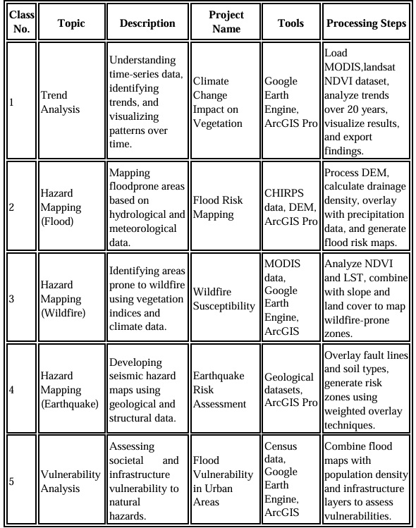
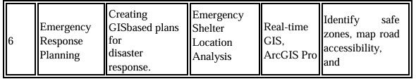
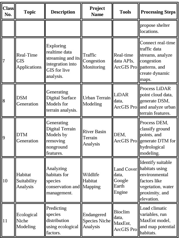

Notes:
Each session includes both theoretical and practical
Students will use sample data to complete hands-on
CAREER OPPORTUNITIES
GIS Analyst | GIS Engineer | GIS Project Manager | GIS Technician | GIS Associate | GIS Consultant | GIS Specialist | Web GIS Developer
Please Note:
- Enrollment Date: You can start the course anytime at your convenience. We follow a flexible admission system, so there are no fixed start dates.
- Class Timings: Considering the time difference between India and other countries, we adjust class schedules to match your availability. Our general slots run between 8:00 AM to 8:00 PM (IST), but timings can be customized to suit your personal or professional commitments.
- Learning Resources & Software Access: Every student will receive a complete package of study support, including:
- GIS exercise databases for practice.
- Softcopies of notes and reference material.
- Recorded lecture access (where applicable).
- Hands-on practice modules and assignments.
- Access to industry-standard GIS software to build practical skills and confidence.
This ensures that your learning experience is smooth, flexible, and highly practical, no matter where you are located.