Live interactive online classes, delivered via Instructor led 1:1 classroom training for the optimum flexibility and convenience.
GIS and Advanced Analytics with Artificial Intelligence (AI) ![]()
Recommended By top faculties


Testimonials
Where Our Training Makes an Impact
Environment & Climate – Biodiversity mapping, carbon monitoring, climate impact studies.
Urban Planning & Smart Cities –Infrastructure planning, land-use mapping, 3D city models.
Agriculture & Forestry – Precision farming, crop monitoring, forest resource management.
Water Resources & Hydrology – Flood risk modeling, watershed management, HEC-RAS simulations.
Disaster Management –Hazard mapping for floods, landslides, and earthquakes using geospatial tools.

GIS Training
Training students and Professionals from India and Abroad to make a career as a GIS Analyst | GIS Engineer | GIS Project Manager | GIS Technician | GIS Associate | GIS Consultant | GIS Specialist | Web GIS Developer

GIS & Remote Sensing Research
Ongoing research on what evolving GIS Industry needs from Freshers as Skills to make them Job Ready and what additional skills can be aquired by professionals to updrade their current skills to excel in their field of expertise.

National & International Standards
Maintaining a PAN India and International Standard of Certification and adding up new MoU Collaborations to help our Students and Professionals get maximum Benefit of our GIS certification Programs.

Academic Partnerships & Workshops
We conduct yearly workshops and Seminars PAN India to bring awareness among the students, faculties and various other stakeholders on how GIS & Remote Sensing can bring in a new revolution in the Industries.
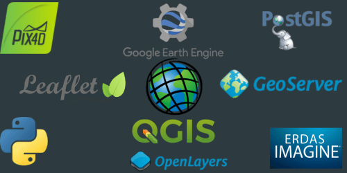
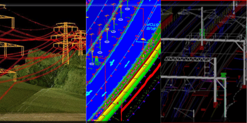
Industry Softwares
We equip our trainees with Industry Best Softwares for Best Results and Outcome in the GIS Industry — from LiDAR Data Processing to 2D Satellite Image Analysis, from GIS Mapping to Web GIS Development.
GIS Training Institute in Pune – Geoinfra Technologies India
If you are looking for the best GIS and remote sensing training institute in Pune, then Geoinfra Technologies India is the right choice. We are an ISO 9001:2015 certified GIS institute providing online GIS training in Pune and Maharashtra with live classes, projects, and placement assistance.
Why Choose Geoinfra GIS Training in Pune?
Live online instructor-led classes (not recorded).
Hands-on GIS training with 1000+ datasets.
Trainers with real industry experience.
Internship opportunities and career support.
ISO-certified courses recognized by companies.
Placement assistance in government and private sector jobs.
GIS and Remote Sensing Courses in Pune
We provide different GIS training courses in Pune designed for students, professionals, and beginners:
15 Days Fundamentals of GIS & Remote Sensing
Learn basics of GIS mapping, satellite image handling, and vector-raster analysis.1 Month GIS Development Training
Covers thematic mapping, database handling, introduction to drone data.Python for GIS (1 Month)
Learn Python scripting for automation, spatial analysis, and building custom GIS tools.Web GIS Training (1 Month)
Covers GeoServer, Leaflet, OpenLayers, and publishing online interactive maps.3 Months Advanced GIS & Remote Sensing
Includes satellite image processing (NDVI, LULC, change detection), DEM analysis, watershed modeling, and project-based learning.6 Months Post Graduate GIS & Remote Sensing Certificate
A complete course including LiDAR data, drone mapping, hydrology, urban planning, cartography, 3D mapping, and research projects.
Who Can Join GIS Training in Pune?
Our GIS courses in Pune are useful for:
Students from Geography, Geology, Environmental Science, Civil Engineering, Disaster Management.
Beginners who want to start a GIS career in India.
Professionals looking to upgrade skills in GIS, remote sensing, or drone mapping.
Career Opportunities After Training
After completing GIS training in Pune with Geoinfra, students can apply for jobs such as:
GIS Analyst
Remote Sensing Specialist
GIS Developer (Python/Web GIS)
Cartographer / Urban Planner
Drone Mapping Analyst
Our alumni are working in government departments, private companies, and research organizations across India.
Placement Assistance
We provide CV preparation, interview guidance, internship opportunities, and placement support. Our courses are designed as job-oriented GIS training in Pune with focus on skills needed by companies today.
Conclusion
For top GIS and remote sensing training in Pune, Geoinfra Technologies India provides ISO-certified online courses, live practical training, and career support. Start your learning journey today and build a strong career in GIS and remote sensing.
📞 Call us: +91 6003787569 | +91 6363595601
📧 Email: info@geoinfratechnologiesindia.com
🌐 Visit: www.geoinfratechnologiesindia.com
