When we think about Thrissur, we think about culture, temples, art, and festivals like Pooram. But apart from being called the cultural capital of Kerala, Thrissur is also growing fast in education, agriculture, and development projects. With this growth, GIS (Geographic Information System) and Remote Sensing training is becoming very important for students and professionals here.
Nowadays, almost every industry is using maps and data together. Whether it is urban planning, agriculture, forest studies, or disaster management, GIS has become the key. That is why learning GIS and Remote Sensing is not just about software skills, it is about preparing for the future.
In Thrissur, many young students from backgrounds like Geography, Geology, Environmental Science, Civil Engineering, and Agriculture are already showing interest in GIS courses. And the best part is that you don’t have to travel far. With live online instructor-led training, you can now join from your own home in Thrissur.
Why GIS Training is Needed in Thrissur
Thrissur is not just cultural, but also a district with rich biodiversity, rivers, paddy fields, and growing towns. Many government departments and private firms here require experts who know GIS.
Some important applications of GIS in Thrissur are:
Agriculture: Crop mapping, pest control, irrigation planning.
Urban Development: Smart city projects, road networks, housing layouts.
Forestry and Environment: Wildlife tracking, forest cover change, biodiversity mapping.
Water Resources: Studying rivers, flood-prone zones, watershed management.
Disaster Management: Flood prediction, landslide studies, risk assessment.
Tourism Development: Mapping heritage sites and tourism zones.
So you can see, GIS is not limited to one sector. Students who learn it can explore multiple opportunities.
About Geoinfra Technologies India
Geoinfra Technologies India, established in 2018, is a well-known institute that provides GIS and Remote Sensing training across India. It is ISO 9001:2015 certified and has trained thousands of students till now.
The main aim is simple: to provide practical-based training with real datasets, not just theory. Many of our students from Kerala and other states have secured jobs in:
Government departments like Survey of India, Forest Departments, and Urban Planning Boards.
Private GIS firms working in IT, construction, and renewable energy.
International NGOs and research projects.
Startups dealing with smart city and sustainability projects.
We follow a student-first approach where training is given step by step, making it easy even for beginners to understand.
How Classes are Conducted
Live Online Classes: Not pre-recorded, but interactive sessions with trainers.
Flexible Timings: Morning, evening, or weekends—students can choose as per their convenience.
1-to-1 Training Option: For those who want personal mentorship.
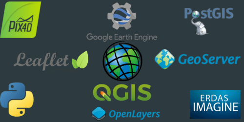
Hands-On Practice: Using professional software like ArcGIS, QGIS, ERDAS, and ENVI.
Study Materials: Access to GIS exercise datasets, notes, and project files.
Certification: After completion, you will receive an ISO-certified certificate.
Courses Offered
We provide different levels of training programs so that students can select based on their background and requirement.
🔹 15 Days Short-Term GIS Training
Best for beginners who want to get a quick understanding of GIS and Remote Sensing.
🔹 1 Month GIS & Remote Sensing Development Training
Good for college students or fresh graduates who want to build strong basics.
🔹 3 Months Advanced GIS & Remote Sensing Training
Includes advanced topics like satellite image processing, water resources study, and climate analysis.
🔹 6 Months Post Graduate Diploma in GIS & Remote Sensing
Full package course with AI, cloud-based GIS, drone mapping, and live projects.
🔹 Web GIS Training
Learn how to publish maps online, handle WMS/WFS services, and build interactive mapping applications.
🔹 Python for GIS Training
Coding and automation in GIS using Python.
🔹 1 Year GIS Analyst Program
Comprehensive program with GIS + Remote Sensing + Data Science, suitable for research or professional career.
Why Choose GIS Training in Thrissur
Here are some reasons why students from Thrissur prefer joining:
ISO Certified Training Modules that meet industry standards.
Experienced Trainers with years of practical exposure.
Flexible Class Schedules suited for both students and working professionals.
Affordable Fees compared to many private institutes.
Placement Support including CV preparation, career guidance, and interview practice.
Practical Learning with real datasets, not just bookish knowledge.
Practical Exposure for Students
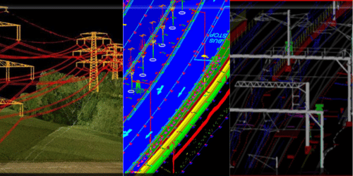
During the course, students will get to practice on:
Drone Survey Data collected from real projects.
Satellite Images from Sentinel, MODIS, Landsat.
GIS Layers Database (1000+ datasets available).
3D Mapping Tools for city planning and environmental studies.
Indices like NDVI, NDWI, EVI for crop and water monitoring.
This way, the students from Thrissur can apply GIS knowledge directly to the local challenges in agriculture, environment, and development.
Career Opportunities After GIS Training
Once you complete the training, you can look for jobs in:
Government Sectors: Forest, Irrigation, Agriculture, Land Records.
Private Companies: IT firms, construction, urban planning consultancies.
NGOs: Environmental and development-focused organizations.
Research Institutes: For academic projects and international collaborations.
Abroad Opportunities: GIS professionals are in demand worldwide.
Job Roles Include:
GIS Analyst
Remote Sensing Expert
Web GIS Developer
Python GIS Programmer
Environmental Consultant
Urban Planner
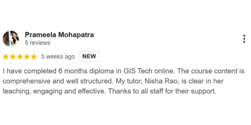
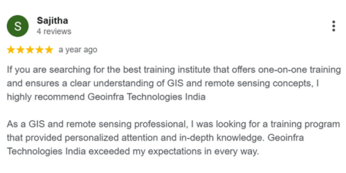
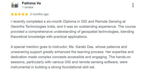
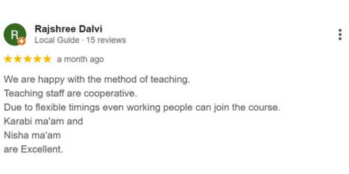
Student Testimonials
👉 “I am from Thrissur and joined the 1-month GIS course. The classes were flexible and the instructor explained every topic clearly. Now I am using GIS for my MSc project.” – Anju, Thrissur
👉 “I joined the 3-month advanced training. The best part was the hands-on practice on satellite images and real case studies. It gave me confidence.” – Rahul, Thrissur
👉 “I had no background in GIS, but the 15 days beginner course gave me a very good foundation. The trainer was patient and solved all my doubts.” – Nandini, Thrissur
How to Enroll
Visit our website and check the course details.
Select the program suitable for your background.
Apply online and confirm admission.
Start your classes at the chosen time.
Complete projects and receive your certificate.
It’s that simple.
Conclusion
Thrissur is known for culture and tradition, but it is also a place where modern technology like GIS can play a big role in agriculture, environment, and city development. By learning GIS and Remote Sensing, students and professionals from Thrissur can open doors to exciting job opportunities not just in Kerala, but across India and abroad.
With Geoinfra Technologies India’s practical and student-focused training, you can gain the skills needed to build a career in the geospatial industry.
👉 If you are from Thrissur and looking for the best GIS training, this is your chance to start today.